
US
°C


A cluster of thunderstorms in the Plains last week tracked through the South and into the Gulf of Mexico.This system became Hurricane Barry.The remnants of Barry will track northward toward the Midwest this week.
By the time we're finished with , it will have traced a fascinating loop from its birth as a disturbance in the Plains to its last breaths as a remnant in the Midwest in over 10 days' time.
Around the Fourth of July, clusters of thunderstorms in the Plains formed their own area of low pressure a few thousand feet above the ground, what meteorologists call a .
While this disturbance was still located over Tennessee on July 6, the National Hurricane Center flagged it for potential tropical development – a rarity for a system still well inland.
This swirling area aloft spawned enough thunderstorms to maintain it as it tracked southeastward across parts of the mid-Mississippi Valley and into the South about a week ago.
Satellite and radar history from July 4 through July 10 of the system that became Barry.
When it emerged over the Gulf of Mexico, its moisture and spin spawned more thunderstorms that eventually triggered the formation of Tropical Storm Barry last Thursday morning.
Barry briefly strengthened into a hurricane Saturday morning, just hours before making landfall.
(MORE: Barry Forecast)
Barry's remnant will continue moving northward, eventually dissipating somewhere over Missouri, according to NOAA's Weather Prediction Center.
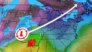
This means Barry may finish up close to the path from when it was an upper-level disturbance over a week before. Its remnants will likely move over that path during the first half of the week.
The white line shows the path of the system that became Barry from July 4 through early July 15.
This is not the first tropical system to have an unusual path.
(MORE: The Weirdest Hurricane and Tropical Storm Paths)
In 2017, Hurricane Harvey stalled over Texas, moved back over the Gulf of Mexico and then toward Louisiana, dumping prolific rain. in 2012 had quite a loopy track over the eastern Atlantic.


