


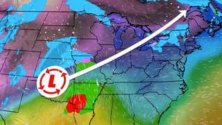
Winter Storm Vulcan deposited a swath of heavy snow from the Midwest into the Great Lakes and interior Northeast, less than two weeks before the arrival of spring 2014.
(MORE: News Recap)
Below is a sampling of the notable snow and high wind reports from this mid-March winter storm, by region:
Peak total: 10.0" in Port Huron, Mich.Toledo, Ohio: 7"Ft. Wayne,Ind.: 6.7"Detroit (Metro Airport):6.6"Duluth (Heights), Minn.:6.4" (mainly from lake-effect snow)Chicago (Midway): 6" (3.6" at O'Hare)Cleveland (Hopkins):3.9"
Vulcan propelled Chicago to its third snowiest season on record, with snow totals ranging from just a dusting in the northwest suburbs to just over six inches in the south suburbs.
Another 6-7 inches in Detroit pushed them to the brink of their record snowiest season, 93.6 inches, set in 1880-1881.
In Toledo, Ohio, Vulcan's snow only added to its record snowiest season. Through March 12, the northwest Ohio city had picked up an incredible 84.8 inches of snow in the season, which was over 51 inches snowier than their average season-to-date snow.
Interestingly, despite widespread ice cover, a small area of open water and sufficiently cold air produced a band of lake-effect snow into the Duluth, Minn. metro area, with amounts over six inches in some areas.
Snow fell at the rate of two inches per hour Wednesday morning at both Chicago Midway and in Ft. Wayne, Ind. Lightning accompanied these intense snowfall rates in parts of northern Indiana, northwest Ohio, Lower Michigan and northeast Illinois.
Van Wert Co., Ohio:Wind gusts to 41 mph, near whiteout conditionsWhitley Co., Ind.:Near blizzard conditions, power outages reported.
Northeast Snow, Ice
Peak snow total: 26" at Sharon, Vt.Burlington, Vt.: 18.7"Caribou, Maine: 16.1"Rochester, N.Y.: 14.9", seventh-heaviest calendar-day snow on record in March; peak wind gust to 52 mphBuffalo, N.Y.: 13.8" at NWS office, fifth-heaviest calendar-day snow on record in March; peak wind gust 47 mph; visibilities reduced to 1/16 mile at Buffalo-Niagara Int'l Airport.Montpelier, Vt.:13"Syracuse, N.Y.: 12.1", eighth-heaviest calendar-day snow on record in MarchIce reports: 0.25" ice accumulation at Cambridge, Gansevoort, Stillwater, Schoarie, Round Lake, Hudson Falls, and Delanson, N.Y. (all in east-central New York)
Buffalo City Hall, as well as Erie County offices were shut down, due to the storm. Numerous reports of lightning came in from the Buffalo metro area early Wednesday afternoon.
Very strong winds accompanied the cold front associated with Winter Storm Vulcan as it swept across the Mid-Atlantic and Southeast Wednesday evening. Selected peak gusts – unless otherwise noted, these were non-thunderstorm gusts:
Grandfather Mountain, N.C.: Sustained west wind of 70 mph with gusts to 86 mph at 6:17 p.m.Camp David in western Maryland: 66 mph at 7:50 p.m. and again at 8:23 p.m.Dulles International Airport, Virginia: 61 mphMartinsburg, W.Va.: 61 mphGreensboro, N.C.: 61 mph during a severe thunderstormBWI Airport outside of Baltimore: 53 mphPhiladelphia: 53 mph at Northeast Philadelphia AirportWashington, D.C.: 52 mphPower outages: At one point Wednesday evening, over 120,000 customers were without power from New Jersey to Georgia on the non-wintry side of Vulcan.
Bob Landon blows snow from a sidewalk in the South End neighborhood on Thursday, March 13, 2014, in Albany, N.Y. Bitter cold temperatures return after a winter storm dumped up to six inches of snow and ice on the Capital Region. (AP Photo/Mike Groll)


 zpostcode
 Recruit
 weather
 mreligion
 Yellowpages
 sport
sport constellation
 shopping
 name
name game
game directory
 literature
 Word
Word tour
tour furnish
 Lottery
 tftnews
 lyrics
 News
News digital
 car
car dir
dir Edu
Edu Finance


