


The powerful nor'easter will produce a host of impacts.Power outages and tree damage could be widespread in some areas.Travel will be difficult, if not impossible at times.Parts of the Northeast coast will see coastal flooding.
A nor'easter will hammer parts of the East Coast into Saturday night with blizzard conditions, high winds and coastal flooding.
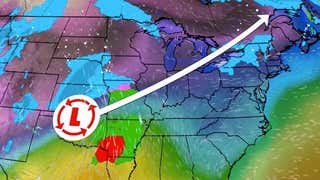
Named Winter Storm Kenan by The Weather Channel, it will morph into an intense low-pressure system that meteorologists refer to as a bomb cyclone.
The latest, complete forecast on the storm is .
This article will focus on the storm's potential impacts – how this storm may affect you.
Saturday, travel will become dangerous, if not impossible, due to heavy snow and potential blizzard conditions in eastern and southern New England, as well as along parts of the Jersey shore southward to the Delmarva Peninsula.
Saturday night, snow will have ended south of Long Island, however, roads will likely still be snow-covered and hazardous, with some blowing and drifting. Snow and high winds will continue in much of New England Saturday night with blizzard conditions along the coast.
Do not travel during this time in these areas; You may become stranded.
The storm will be over by Sunday morning but snow-covered, hazardous roads are still likely in New England southward to the Delmarva Peninsula.
Major airport delays and cancellations can be expected at the major Northeast hubs into the weekend, particularly Boston-Logan, LaGuardia, JFK, Newark and Philadelphia.
High winds are most likely into Saturday night from eastern Long Island to areas near the coast in New England, including Block Island, Martha's Vineyard, Nantucket and Cape Cod.
These winds – combined with the weight of heavy snow – may down trees and power lines, leading to numerous power outages that could last for several hours in these areas. Downed trees may also block roads.
At least some downed tree limbs and power outages are also expected from the New York City tri-state area southward to parts of the mid-Atlantic coast into Saturday night.
(MORE: What to Do If Your Power and Heat Go Out in the Winter)
In general, coastal flooding is expected during the Saturday high tides.
Minor to moderate coastal flooding is possible from eastern North Carolina and southeastern Virginia to Massachusetts.
Some coastal roads susceptible to flooding may become impassable at times of high tide Saturday. Some beach erosion is also possible.
A few communities from Norfolk to Cape May could see widespread flooding along the immediate coast, which may include inundation of coastal structures.
A few areas from South Carolina to southern New England may experience minor coastal flooding again around Sunday morning's high tide, but water levels should subside after that.
Sunday morning lows will bottom out in the teens or single digits, while highs will rise into upper 20s, at most, in the storm-affected areas from New Jersey to New England. Lows Monday morning may be about as cold as Sunday morning.
(MAPS: 10-Day U.S. Forecast Highs and Lows)
This lingering cold could keep roads slippery – at least side streets and stretches of other roads – into early Monday.
Highs are forecast to warm into the 30s Monday afternoon from southern New England into the New York City tri-state area, allowing some remaining snow to melt.
Farther south highs Sunday afternoon may rise into the 30s or low 40s in Virginia and North Carolina, allowing some melting during the day. However, lows Monday morning will plunge well into the 20s, which could lead to refreezing of any melted snow or ice on roads for the Monday morning commute.
The Weather Company’s primary journalistic mission is to report on breaking weather news, the environment and the importance of science to our lives. This story does not necessarily represent the position of our parent company, .


 zpostcode
 Recruit
 weather
 mreligion
 Yellowpages
 sport
sport constellation
 shopping
 name
name game
game directory
 literature
 Word
Word tour
tour furnish
 Lottery
 tftnews
 lyrics
 News
News digital
 car
car dir
dir Edu
Edu Finance


