


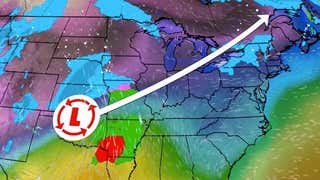
An area of low pressure just off the Eastern Seaboard is interacting with just enoughcold air to result in some accumulating snow and ice from the Appalachians through portions of the Northeast.
Current Radar
Monday Forecast
Most of the Northeast I-95 corridor is seeing mainly rain from this storm system. However, a few pockets of snow were reported in the Baltimore and Washington, D.C. areas on Sunday afternoon.
Below is a look at what to expect from this latest winter storm.
Timing and locations: Through Monday for parts of New England, and into Monday night for parts of coastal eastern New England.Precipitation types: While there may be a narrow stripe of plain snow, most areas will either see just rain (close to the coast) or a mixed back of snow, sleet, and freezing rain, along with possibly some rain. See inset maps and your local forecast page for specifics.Snow, ice amounts: Patchy additional snow accumulations of 1 inch possible in northern and eastern Maine.In parts of this zone, ice glaze of one-tenth to one-quarter of an inch is possible. A widespread damaging ice storm is not expected.Possible impacts: Slick travel conditions, particularly over bridges and overpasses in areas with a thin glaze of ice accumulation in parts of interior New England.Winds: North winds of 15 to 30 mph are expected in many of the above-mentioned areas through Monday.


 zpostcode
 Recruit
 weather
 mreligion
 Yellowpages
 sport
sport constellation
 shopping
 name
name game
game directory
 literature
 Word
Word tour
tour furnish
 Lottery
 tftnews
 lyrics
 News
News digital
 car
car dir
dir Edu
Edu Finance


