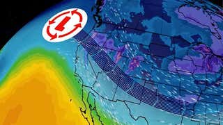


Yet another winter storm is targeting parts of the Plains and Upper Midwest with potentially heavy snow early this week. This system could become our next named winter storm "Delphi" .
Forecast location of the upper-level low pressure system on Tuesday in the Great Lakes. This system stalled in the Great Basin over much of the Thanksgiving holiday weekend.
Low pressure in the upper atmosphere has been stuck swirling over the Great Basin during the Thanksgiving holiday, trapped to the south of a corresponding area of high pressure aloft in an atmospheric logjam known to meteorologists as a "".
As a result, the weather had been rather stagnant and unchangeable, with periods of freezing rain, sleet and snow persisting in the Plains, and of .
Now, that blocked-up jet stream pattern is finally giving way.
The upper-level low mentioned above will finally pivot east into the Midwest early in the week ahead. As it does so, moisture in the atmosphere will be lifted, and cold air in place will yield a swath of snow from late Sunday into Tuesday night from the High Plains to the Corn Belt, Upper Mississippi Valley and northern Great Lakes.
Winter storm watches have already been posted for portions of eastern Nebraska, southeast/south-central South Dakota, southern Minnesota and northwest Iowa, meaning the possibility exists for snowfall amounts greater than 6 inches within the next 48 hours. Those watches include the Minneapolis/St. Paul, Sioux City, Iowa, and Sioux Falls, South Dakota, metro areas. Winter weather advisories are in effect farther south, across southern Nebraska and northwestern Kansas, where somewhat lower snowfall totals are anticipated.
(MAPS:)
Snow spreads from the Colorado High Country into eastern Colorado, western Kansas, western/central/northeast Nebraska, southeast South Dakota, northwest Iowa and far southwest Minnesota.
In addition, some sleet or freezing rain is possible to the east of that snow area from northwest Oklahoma to central Kansas, southeast Nebraska and central Iowa.
Snow, possibly heavy, continues in parts of the northern and central Plains, including South Dakota, southeast North Dakota, Nebraska, parts of northwest Iowa, central and southern Minnesota and far northwestern Kansas. Mixed wintry precipitation is expected from southeast Nebraska to central Iowa and far southeast Minnesota.
This may lead to a challenging morning commute inand , Nebraska. Monday afternoon's commute may be tricky in,, and.
Snow continues Monday night across northern Nebraska, South Dakota, southeast North Dakota, Minnesota, northwest/western Iowa and northern Wisconsin. Some blowing and drifting snow is possible in the Dakotas and Nebraska Monday night.
Travel should be avoided in the areas mentioned above Monday night, including I-35, I-94, I-90 and I-29.
Leftover snow is possible in the northern Great Lakes and Upper Midwest, from Michigan's Upper Peninsula to northern Wisconsin, Minnesota, Iowa and parts of the Dakotas.
This has the potential to disrupt both the morning and afternoon commutes in, and leftover snow and wind in the morning could also pose problems in.
How Much Snow?
With some uncertainty remaining in the forecast depending on how the storm system evolves, here is the general snow total outlook through Tuesday night:
At least 6 inches of snow possible: parts of northeast Nebraska, eastern South Dakota, extreme southeast North Dakota, northern Iowa, southern and central Minnesota, and northwestern Wisconsin.Lighter snowfall possible: Northern Minnesota, Colorado, northern New Mexico, western/northern Kansas, western/central/southern Nebraska, western South Dakota, south-central North Dakota, central/southwest Iowa, northeast Wisconsin and the Upper Peninsula of Michigan.
(FORECASTS:||)
Parts of southeast South Dakota, northeast Nebraska and northern Iowa just finished digging out from , which dumped up to 18 inches of snow near Sioux Falls last weekend.
At the same time, Minneapolis/St. Paul finally picked up its , their .
Interestingly, according to the National Weather Service, .
The last snowstorm of 6 inches or more in the Twin Cities (airport) was April 3-4, 2014. The last official 10 inch snowstorm at the airport was Dec. 9, 2012 when 10.5 inches accumulated.
MORE ON WEATHER.COM: Winter Storm Bella (PHOTOS)
Ice-covered limbs hang near the ground as traffic passes by Saturday, Nov. 28, 2015, in Oklahoma City. (Jim Beckel/The Oklahoman via AP)


