


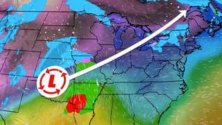
Low pressure intensified rapidly off the U.S. East Coast on March 26, 2014, becoming a sprawling, powerhouse ocean storm as it tracked into Atlantic Canada later in the day.
Fortunately for most of the East Coast, this storm tracked outside the so-called 40/70 benchmark, namely, 40 degrees north latitude and 70 degrees west longitude, to keep the most severe impacts pinned mainly to Cape Cod, Martha's Vineyard, Nantucket Island, and Downeast Maine.
Incidentally, you may be curious why we did not give this storm a name.
"Our process to name winter storms is based on the impacts that occur across the U.S.," said Tom Niziol, winter weather expert at The Weather Channel (Twitter | Facebook). "We asess those impacts based on the population and areas that are under National Weather Service warnings or advisories or anticipated to be so."
"In order for the storm to be named, we need at least 2.5 million people under warnings and 10 million people under warnings and advisories. In this case, area and population anticipated to be under winter storm warnings was not large enough to satisfy the naming criteria," said Niziol.
(MORE: Science Behind Naming Winter Storms at The Weather Channel)
Central pressure and track history of the Mar. 25-26, 2014 nor'easter.
Tuesday, March 25:
Snow fell from the Great Lakes to the Ohio Valley, Appalachians and Middle Atlantic.Flurries reported as far south as northern Georgia.Largest snow totals: 12.2" near Beech Mountain, N.C.; 8 to 12" at Black Mountain, Ky.; 7.5" near Davis, W.V.; 7.2" in Dennisville, N.J.; 7" near Lynchburg, Va.; 7" in Frankford, Del.Other notable snow amounts: 3.8" at Washington - Dulles Airport; 1.7" at Washington - National Airport; 2.8" in Roanoke, Va.; 1.3" in Charleston, W.V.
Wednesday, March 26:
Wind gust to 83 mph reported on Nantucket Island Wednesday morning. Gust to 71 mph reported on Cape Cod in Harwichport, Mass.Heavy snow and 1/4 mile visibility reported on Cape Cod, Nantucket and Martha's Vineyard Wednesday morning.Blizzard conditions were achieved on Martha's Vineyard Wednesday morning.As of midday Wednesday, Nantucket reported 9.5 inches of snow.Coastal flooding in Plymouth, Sandwich, Scituate, Chatham and Dennis, Mass., as well as on Nantucket Island.Tree branches and power lines down on Cape Cod and Nantucket, parts of the Boston metropolitan area, and parts of Downeast Maine, including Bar Harbor.NOAA buoy 44027, located 23 miles southeast of Jonesport, Maine, reported a wind gusts of 119 mph at 1:49 p.m. EDT Wednesday.In Canada, a sustained wind of 70 mph and a gust of 107 mph was reported at Grand Etang, Nova Scotia, Wednesday afternoon.Wreckhouse, Newfoundland, reported a peak gust of 115 mph with sustained winds as high as 87 mph early Wednesday evening.Several other Nova Scotia locations reported sustained winds above 60 mph and gusts over 80 mph.Central pressure of the storm fell 26 millibars in 9 hours, easily satisfying "bombogenesis" criteria.The 45 millibar pressure drop in 24 hours exceeded that of the1978 ClevelandSuperbomb.The lowest estimated central pressure of 955 millibars equaled the lowest pressure of the1978 ClevelandSuperbomb, and was lower than the minimum pressure of the1993Superstorm.
(INFOGRAPHIC:Pressure Records...Earth's Strongest Storms)
A swing set is seen at Veterans Park Beach during a snowstorm March 26, 2014 in Hyannis, Mass. Darren McCollester/Getty Images)


 zpostcode
 Recruit
 weather
 mreligion
 Yellowpages
 sport
sport constellation
 shopping
 name
name game
game directory
 literature
 Word
Word tour
tour furnish
 Lottery
 tftnews
 lyrics
 News
News digital
 car
car dir
dir Edu
Edu Finance


